-40%
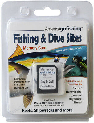
Bay and Gulf Counties Fishing & Dive Sites Memory Card
$ 34.31
- Description
- Size Guide
Description
Fishing and Dive Sites Memory CardPublic waypoint files for Garmin
®
, Lowrance
®
, Raymarine
®
, Humminbird
®
, Simrad
®
Bay & Gulf Counties -
Over 360 GPS Waypoints!
Panama City, Mexico Beach, Port Saint Joe and more.
Fishing & Dive Sites memory cards are a must have for anyone visiting reef sites in Florida!
This set of data files with GPS coordinates is ready to use on your GPS unit, computer, tablet & smart phone.
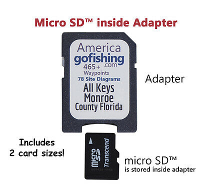
Data Files for All Your Devices on a microSD™ stored Inside SD™Adapter - 2 Card Sizes!
Includes 1 file set for each area indicated on memory card label.
Our data files are unique because we have brought public data from dozens of resources into one place. We formatted this data for easy import into the most popular GPS brands then created companion PDF & KML files that are great planning tools. We also include rules and regulations for many reef sites (if available/varies by county), a unique feature not found elsewhere.
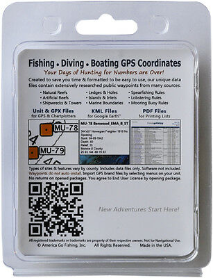
Fishing – Diving – Boating
(Included sites & features vary by county)
• Artificial Reefs
• Ledges & Holes
• Mooring Buoy Rules
• Natural Reefs
• Islands & Inlets
• Lobstering Rules
• Shipwrecks
• Marine Boundaries
• Spearfishing Rules
Your Days of Hunting for GPS Numbers Online Are Over!
Your Time is Valuable!
Why waste it hunting for online numbers then manually entering GPS coordinates into your GPS unit. Our GPS files make it easy to import numbers into your GPS unit, print from your computer or smartphone, and explore sites in satellite view. Finding nearby sites and planning your next trip couldn't be easier. No more wasted time searching the internet for new fishing or diving spots, we've done the work for you.
FEATURES
Our GPS coordinate files are a compilation of public waypoints, created to save you time!
A must have for anyone visiting offshore reef sites. Great for fishing, diving, snorkeling and boating!
Data Files
on our memory card include files for your
GPS unit brand
and one
,
KML
&
GPX
file for each area indicated on card label. Several files are included for your GPS brand that work with new and older models that accept SD
TM
cards. See "
Data Files Included
" below for a list of files included.
Our GPS fishing chip contains all the files you will need to plan your next trip or find more sites while out on the water.
Data Files Included
(1 of each file type for each county included)
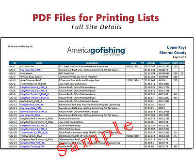
Print the PDF companion waypoint list(s) found in the PDF folder. Use this list to look up the full site details. Send PDF files to your phone to have site info handy while out on the water.
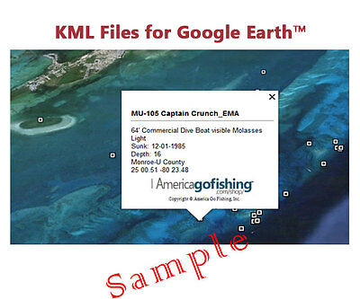
Use the KML files on your computer or phone using the free Google Earth
®
software. See the sites in satellite view, measure distances, and plan your next trip.
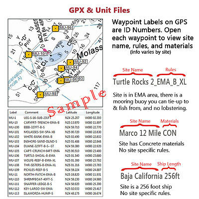
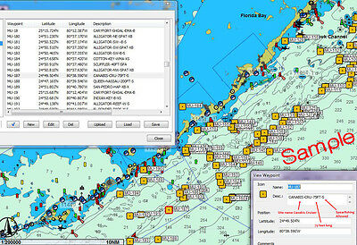
Simply select menus on your GPS Unit/Chartplotter unit to import waypoints from SDh™. Your unit will show the site ID numbers on top of your maps. Open the site on your unit to see site name & brief details.
Unit Files
Garmin
®
, Humminbird
®
, Lowrance
®
, Raymarine
®
, and Simrad
®
. Upload GPS Coordinates to your unit's Waypoint List.
GPX Files
Universal format for importing waypoints into modern devices
KML Files
View satellite images of sites & marine boundaries with popup details using the free Google Earth
®
PDF Files
Print tabular lists of waypoints, chart key, license, and user guide using the free Adobe Acrobat
®
Bonus!
Every package includes bonus KML files. Our
exclusive
, in-house created,
Marine Boundaries
KML file shows all federal marine zones in the southern Atlantic Ocean & Gulf of Mexico. The
State Boundaries
KML file, courtesy of FWC, shows you the dividing line between state and federal waters, a great planning aid. The Keys chips include a monroe-waterway_navigation_routes_from_NOAA_charts.kmz file.
GPS/Chartplotter Unit Files
We offer files for the most popular GPS brands: Garmin
®
, Humminbird
®
, Lowrance
®
, Raymarine
®
, and Simrad
®
.
GPS Coordinates upload to your GPS/Chartplotter unit's Waypoint List in seconds!
We include many files for your GPS brand. Your unit will recognize 1 or more files on the chip.
Only import 1 file
as they all contain the exact same data. Always backup your units data to a blank card before importing our waypoints.
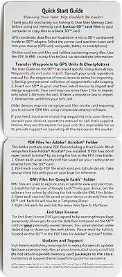
Transferring Waypoints to Your GPS Unit
Your unit must accept SD™ memory cards; we include 2 sizes that work with most modern devices. Simply insert the correct size memory card into your unit then select the appropriate menu items to import and merge waypoints into your unit. After the waypoints are uploaded, remove the chip from your unit.
Our chips are not software and do not self-install
; you must manually select menu items on your GPS unit to import waypoints. We include a detailed instruction sheet, a User Guide and GPS brand instructions. Please refer to your units operating manual for instructions on how to upload waypoints to your unit; we do not provide support on how to use your unit or its software.
SITE FEATURES
PDF & KML
files include date sunk, description/materials, latitude, longitude, depth, relief, and links to more site information (if available/varies by site.)
Unit files and GPX
files include 4 fields: name, description/materials, latitude, and longitude. Some unit files include the depths but not many due to import constraints. You will see a Site ID number on your unit maps. Open the waypoint to see the site Name and brief description of Materials. Limited data is imported into your unit and you can later change the Site ID number to a name you prefer. Product images above show of how sites will appear on your GPS unit.
What Sites Are Included?
The types of waypoints included vary by county and may include artificial reefs, natural reefs, shipwrecks, ledges & holes, island & inlets, marine boundaries, and mooring buoys.
Updates
We update our GPS lists of waypoints in the fall months. Once a county is complete we add any new sites to our website lists and mark them with New!. Usually there are only a small number added to some areas, so you can easily key them into your unit.
Many areas rarely have site changes or additions so you may receive data files that are dated as far back as 2014. The time it took you to type a few waypoints, you could have imported hundreds!
Sure, you can use our numbers online for free, but do you really want to spend your valuable time typing in hundreds of waypoints? And how convenient is it to have nearby site numbers ready when you need them, numbers you never thought you would use
.
Secret Spots
There are NO secret sites in our data files. All waypoints are for public sites acquired from many sources. An enormous amount of time has been spent researching the thousands of waypoints on our lists making them very unique.
GPS Coordinates Format GPS units & software programs will automatically convert our file formats to your Lat/Long default setting. Our files are in the following formats:
— PDF & KML Files: Lat/Long Decimal Minutes (dd mm.mmm)
— Unit & GPX Files: Lat/Long Decimal Degrees (dd.dddddddd)
ACCURACY OF COORDINATES
Due to the Increased and Severity of Recent and Past Hurricane Activity, it is Very Possible Coordinates May Not Be Accurate.
America Go Fishing cannot guarantee accuracy of coordinate data contained in data files. However, America Go Fishing constantly performs reef monitoring through volunteer reef report submissions and communications with reef stakeholders to verify locations of artificial reefs and produce the closest waypoint coordinates possible. Please understand that smaller reefs can be very difficult to locate with GPS and depth sounders because they are small targets that can be challenging for highly experienced navigators to find. Storms and other natural events can relocate sites and the effects of saltwater can erode a site making identification difficult. With these factors in mind and other unknown circumstances, we cannot guarantee the accuracy of our files, content or coordinates.
Disclaimer
Not for Navigational Use. Rules change frequently, always inquire locally before fishing, Lobstering, or spearfishing. GPS coordinates are not guaranteed because it is very possible numbers may be off due to equipment & software interpretation of numbers and the severity of recent & past hurricane activity which can bury or relocate sites. There are NO guaranties, warranties, express or implied, or representations as to the accuracy of the content contained in data files. America Go Fishing assumes NO liability or responsibility for any errors or omissions in the information contained in data files. You agree to our End User License by opening our package. You can read the End User License online (indicated on the package) before opening.
Maps & Nautical Charts
Files on this card contain waypoint locations only - maps and nautical charts underlay our waypoints when viewing in YOUR software or on your GPS unit.
Software
Application software must be pre-installed to use PDF & KML data files. Free software available. Most manufacturers provide free or low cost software to manage waypoints on your computer.
License
You agree to our End User License by opening our memory card package. Once opened, memory card packages are not returnable. You are permitted to use our files on all YOUR personal devices. You are prohibited from sharing or duplicating our files which are protected by international patent and copyright laws. We will aggressively pursue prosecution of any unlawful distribution of our copyrighted data files.
No SD™ Slot on Your Computer?
If your device does not accept SD™ memory cards you can use a SD™ to USB Memory Card Reader, sold separately.
Unsure about buying our charts?
We can send you our FREE Walton County individual files and you can give them a test drive. We can also send you brand specific files to try, just email us.
Data Files Included
Files for Your Unit: Garmin
®
, Humminbird
®
, Lowrance
®
, Raymarine
®
, and Simrad
®
county.gpx
county.kml
county.pdf
marine-protected-areas.kml
state-boundaries.kml
user-guide.pdf
transfer-waypoints-to-GPS.pdf
chart-key.pdf
end-user-license.pdf
Fast Shipping!
A great gift for fishing & diving enthusiasts!
You don't even need a GPS unit to use these files - most computers, smart phones & tablets read our data files
.
Terms & Conditions
Once a bid has been placed, it is a legally binding contract of purchase.
Sales tax is charged for products shipped to Florida.
Payment for auctions must be received within
4 working
days of purchase and immediately for Buy It Now items.
If payment is not received within
7 days
of purchase then a "Non Paying Buyer Dispute" will be filed, and 10 days later a final fee credit lodged.
Once you receive your order, please inspect items for any damage during transit and report the any damage within 24 hours via e-mail.
No Returns Accepted.
Fast Shipping! We ship within 24 hours via USPS Priority Mail. We will always combine shipping when possible.
You will be notified via Email when your order is shipped. You can track your order by clicking the link in the Email. We accept no responsibility for goods delayed once they are shipped.
7 days after we have shipped your order, if we have not been notified by you of any problem, or received feedback, we will send a feedback reminder.
Our goal is to maintain our reputation of having
100% satisfied customers!
If you are happy with our product, please send us your positive feedback. If you have any problems or comments, contact us first before leaving feedback.
America
gofishing
has been helping people find more places to fish & dive since 2010
Buy with confidence from a trusted corporation
-
See our
About
m
e
&
Our Other Items
